Kerrville, Texas, August 26, 2025
News Summary
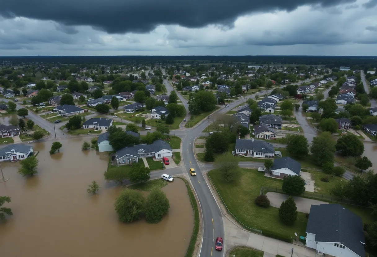
Severe flooding in Central Texas struck unexpectedly on July 4, resulting in at least 69 fatalities in Kerr County. The Guadalupe River rose dramatically by 26 feet within just 45 minutes, causing widespread devastation. Despite prior flood watches and warnings issued by the National Weather Service, many residents faced challenges in evacuating due to the rapid onset of flooding and communication gaps. Search and rescue efforts are ongoing, with local, state, and volunteer teams working to assist affected communities.
Kerrville, Texas — Severe overnight flooding struck Central Texas around midnight on July 4, 2025, killing at least 69 people in Kerr County and leaving an unknown number still reported missing. The flooding was sudden and extreme: the Guadalupe River rose 26 feet within 45 minutes, overwhelming low-lying areas and causing widespread damage. Authorities and federal officials are facing scrutiny over whether emergency alerts and preparedness measures reached residents in time.
Key facts and immediate impact
Thunderstorms that developed around midnight on July 4 produced intense rainfall in parts of Central Texas. The National Weather Service (NWS) had issued a Flood Watch on July 3 predicting 5 to 7 inches of rain, and began issuing Flash Flood Warnings at 1:14 a.m. on July 4. Those warnings included urgent language urging residents to move to higher ground as flood emergencies were declared in affected areas.
Despite warnings, the speed and location of rainfall exceeded local impacts expected from the forecast. The rapid river rise and inundation of roads and neighborhoods complicated rescues and evacuation. Cell phone coverage gaps in some areas likely hindered delivery of alerts and emergency communication.
Response and operational details
State emergency resources had been positioned in Kerr County beginning on July 2 in anticipation of severe rainfall. During the event, the NWS office serving the area increased staff on duty from two forecasters to five to manage warnings and supplemental messaging. Federal and state leaders acknowledged the difficulty of predicting precise locations and intensities of extreme rainfall.
Volunteer groups and local relief organizations mobilized to assist affected residents with search, rescue, and recovery needs. Damage was extensive across impacted communities, with roads and property submerged or washed out.
Questions raised about alerts and preparedness
Concerns have emerged regarding the timing, number and effectiveness of emergency alerts. Officials and residents noted that some people in affected areas did not receive alerts or had insufficient time to evacuate. Investigations and reviews of alert systems, mobile delivery, and coverage gaps are expected as part of recovery and after-action processes.
Humanitarian and recovery efforts
Local, state, and volunteer teams are assisting with immediate relief needs, including search and rescue, sheltering, and distribution of supplies. Long-term recovery planning will address infrastructure repair, communications improvements, and flood mitigation as communities assess damage.
Background and context
Flash floods can develop rapidly during intense thunderstorms, creating dangerous conditions in minutes. While forecasts can provide a general sense of risk, pinpointing exact locations and rainfall amounts for sudden, extreme downpours remains challenging, particularly in hilly or rural terrain where rivers can rise quickly. The event in Kerr County illustrates how rapidly evolving weather and communication gaps can combine to increase hazard to life and property.
What officials have said about forecasting and response
State authorities noted they deployed assets before the storm based on predicted weather patterns, while state and federal officials acknowledged limitations in forecast precision for extreme rainfall events. Emergency managers and meteorologists emphasize ongoing work to improve warning delivery, redundancy in communications, and public awareness of rapid-onset flood risk.
| Key Feature | Detail |
|---|---|
| Event | Severe flooding in Kerr County and Central Texas |
| Date | Flooding began shortly after midnight, July 4, 2025 |
| Fatalities | At least 69 confirmed |
| River rise | Guadalupe River rose 26 feet in 45 minutes |
| NWS actions | Flood Watch July 3; Flash Flood Warnings beginning 1:14 a.m. July 4; added staff at New Braunfels office |
| Preparedness | State assets staged in Kerr County starting July 2 |
Timeline of major events
| Date / Time | Event | Status / Source |
|---|---|---|
| July 2, 2025 | State positions assets and resources in Kerr County ahead of forecasted storms | State emergency planning |
| July 3, 2025 | National Weather Service issues Flood Watch predicting 5–7 inches of rain | NWS forecast |
| Shortly after midnight, July 4, 2025 | Thunderstorms begin producing intense rainfall in Central Texas | Local observations / warnings |
| 1:14 a.m., July 4, 2025 | NWS issues Flash Flood Warnings and urgent messages to move to higher ground | NWS warnings |
| Within ~45 minutes after midnight, July 4, 2025 | Guadalupe River rises 26 feet, triggering extreme flooding | Hydrologic observations |
| During event | NWS New Braunfels increases forecasters on duty from two to five | NWS operations |
| Aftermath (ongoing) | Search and rescue and relief efforts; reviews of alert effectiveness | Local, state, volunteer response |
Simple visual statistics
FAQ
How many people died and are still missing?
At least 69 people have been confirmed dead in Kerr County. An unknown number of people remain reported missing as search and rescue efforts continue.
When did the flooding begin and what caused it?
Thunderstorms began producing heavy rainfall around midnight on July 4, 2025. Intense rainfall caused rapid river rises and flash flooding, including a documented 26-foot rise of the Guadalupe River within about 45 minutes.
Were warnings issued before the flooding?
Yes. The National Weather Service issued a Flood Watch on July 3 predicting 5 to 7 inches of rainfall and began issuing Flash Flood Warnings and urgent messages at 1:14 a.m. on July 4, urging residents to move to higher ground.
Did officials pre-position resources?
State officials placed assets and resources in Kerr County beginning on July 2 based on predicted weather patterns. Additional support from local and volunteer organizations has been mobilized during the response.
Why did some people not receive alerts?
Multiple factors likely contributed, including the difficulty of forecasting exact storm locations and intensities, the very rapid onset of flooding, and gaps in cell phone coverage in some affected areas that may have prevented delivery of mobile alerts.
Deeper Dive: News & Info About This Topic
HERE Resources
Community Comes Together to Support Family After Tragic Accident
Amber Alert Issued for Missing 3-Year-Old in San Antonio
AMBER Alert Issued for 3-Year-Old in San Antonio
Texas Education Agency Releases New Accountability Ratings
Texas Confronts Weather Threats and Legislative Action
Texas House Set to Vote on Congressional Redistricting
West San Antonio Expands Local Moving Services
Man Arrested for Homicide After Stabbing Outside Dance Hall
Texas Education Agency Releases Accountability Ratings for San Antonio Schools
Family-Friendly Weekend Events in San Antonio
Additional Resources
- NBC DFW News
- Google Search: Texas flooding timeline
- Politico
- Wikipedia: Flood warning
- WSVN News
- Encyclopedia Britannica: Weather forecast accuracy
- The New York Times
- Google News: Texas floods July 2025
- Click2Houston
- Google Scholar: Flooding impact analysis

Author: STAFF HERE SAN ANTONIO WRITER
The SAN ANTONIO STAFF WRITER represents the experienced team at HERESanAntonio.com, your go-to source for actionable local news and information in San Antonio, Bexar County, and beyond. Specializing in "news you can use," we cover essential topics like product reviews for personal and business needs, local business directories, politics, real estate trends, neighborhood insights, and state news affecting the area—with deep expertise drawn from years of dedicated reporting and strong community input, including local press releases and business updates. We deliver top reporting on high-value events such as Fiesta San Antonio, San Antonio Stock Show & Rodeo, and Dia de los Muertos. Our coverage extends to key organizations like the Greater San Antonio Chamber of Commerce and United Way of San Antonio and Bexar County, plus leading businesses in retail, insurance, and energy that power the local economy such as H-E-B, USAA, and Valero Energy. As part of the broader HERE network, including HEREAustinTX.com, HERECollegeStation.com, HEREDallas.com, and HEREHouston.com, we provide comprehensive, credible insights into Texas's dynamic landscape.