News Summary
Severe thunderstorms struck San Antonio on Memorial Day night, bringing hazardous conditions including large hail and heavy rain. Areas faced flash flood warnings, with forecasts expecting further rainfall. Residents are urged to remain vigilant and prioritize safety as additional storms are anticipated.
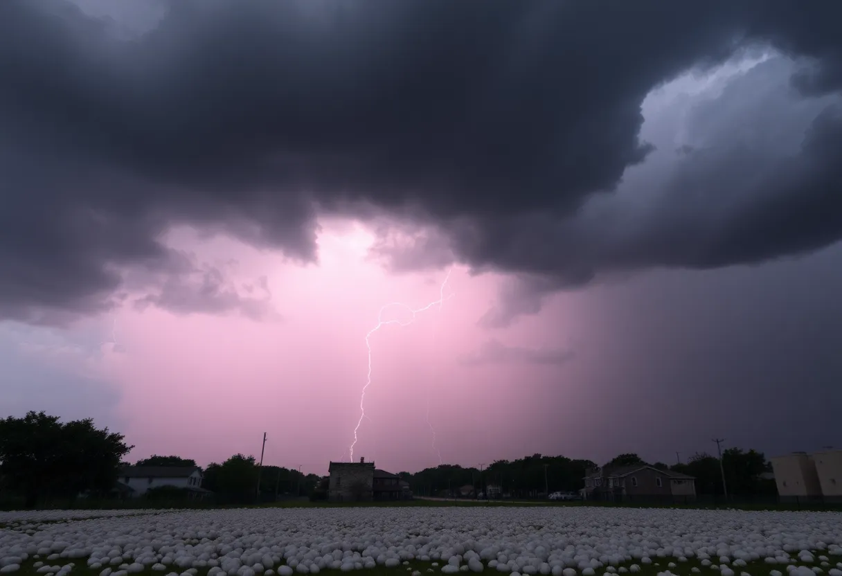
San Antonio – Severe thunderstorms struck the San Antonio region on Monday night, delivering intense weather conditions that included hail ranging from golf balls to grapefruit in size. This extreme weather marked a turbulent end to Memorial Day as neighborhoods on the northwest and far west sides of the city faced the brunt of the storms, which were accompanied by lightning and heavy rainfall.
Under a Level 2 out of 5 risk for severe storms, the weather event commenced around 8 p.m., transforming from flashes of lightning to thunder and subsequently, heavy rain. Reports indicated that San Antonio has received only half of the typical rainfall expected by this point in 2025, creating concerns over the already limited water supply in the area.
As the storms progressed, several counties—Bexar, Comal, Guadalupe, and Hays—were placed under a flash flood warning until 3 a.m. on Tuesday, due to flood risks heightened by rain accumulation. Areas in northern Bexar County received up to 2 inches of rain, with forecasts predicting another 1-3 inches could fall, exacerbating concerns about flooding.
Travel was heavily discouraged, with authorities urging drivers to avoid flooded roadways to ensure safety. The risk of flooding and severe weather prompted a precautionary response in the community. Earlier in the evening, a tornado warning that had been issued for Blanco and Hays counties was subsequently canceled, indicating a shift in the storm conditions.
The line of strong to severe thunderstorms extended from Boerne northeast to Killeen, severely affecting the I-35 corridor. The National Weather Service had initially issued a tornado watch for several counties until 10 p.m., signaling conditions favorable for tornado formation. Reports confirmed that as of 6:45 p.m., a severe thunderstorm producing golf ball-sized hail was advancing into Gillespie County, further indicating the widespread impact of the storm system.
Areas under the tornado watch included Bexar, Atascosa, Bandera, and numerous surrounding counties, highlighting the extensive reach of the severe weather event. The main threats associated with the storms included large hail and damaging winds, with strong gusts noted from a “Wake Low” phenomenon following the storms, potentially reaching speeds of 40 mph or higher.
While the risk for severe storms in Bexar County was deemed over following the heavy rainfall and hail, new weather predictions indicated that additional storms are anticipated late Tuesday into Tuesday night, particularly in the western parts of the area, with a projected eastward movement.
Residents are continually advised to remain vigilant regarding weather alerts and prepare a contingency plan for shelter in anticipation of future severe weather. The unpredictable nature of this storm season has heightened awareness and concerns among the community, prompting a cautious approach as weather patterns evolve.
In summary, the severe thunderstorms that pounded San Antonio on Memorial Day night have left behind significant weather-related challenges, and further storms appear imminent in the coming days. Community members are urged to stay informed and prioritize safety amid these conditions.
Deeper Dive: News & Info About This Topic
HERE Resources
Dallas Cowboys Cheerleaders Performance and Auditions in San Antonio
San Antonio Faces Severe Heat and Thunderstorm Alerts
Southwest Airlines Implements New Charger Policy for Safety
Severe Weather and How Texas Residents Should Prepare for Memorial Day Weekend
Texas Businesses Face Tough Times as Tariffs Loom
Severe Storms Cause Significant Tornado Damage in Central Wisconsin
Major Crash Disrupts Traffic on I-35 in San Antonio
Southeast Faces Major Flooding Threat as Atmospheric River Hits
Severe Hailstorms Hit San Antonio Causing Major Disruptions
Severe Thunderstorm Watch Issued for San Antonio
Additional Resources
- KSAT News
- Wikipedia: San Antonio
- News 4 San Antonio
- Google Search: severe storms San Antonio
- KENS5 News
- Google Scholar: hail storms San Antonio
- San Antonio Express News
- Encyclopedia Britannica: weather patterns Texas
- KSAT Weather
- Google News: Tornado Watch Texas

Author: STAFF HERE SAN ANTONIO WRITER
The SAN ANTONIO STAFF WRITER represents the experienced team at HERESanAntonio.com, your go-to source for actionable local news and information in San Antonio, Bexar County, and beyond. Specializing in "news you can use," we cover essential topics like product reviews for personal and business needs, local business directories, politics, real estate trends, neighborhood insights, and state news affecting the area—with deep expertise drawn from years of dedicated reporting and strong community input, including local press releases and business updates. We deliver top reporting on high-value events such as Fiesta San Antonio, San Antonio Stock Show & Rodeo, and Dia de los Muertos. Our coverage extends to key organizations like the Greater San Antonio Chamber of Commerce and United Way of San Antonio and Bexar County, plus leading businesses in retail, insurance, and energy that power the local economy such as H-E-B, USAA, and Valero Energy. As part of the broader HERE network, including HEREAustinTX.com, HERECollegeStation.com, HEREDallas.com, and HEREHouston.com, we provide comprehensive, credible insights into Texas's dynamic landscape.